







Undermaps Ingest Logomark

AS-BUILT AND BYDA DIAL DIGITISATION,
DONE AUTOMATICALLY.

AS-BUILT AND BYDA DIAL DIGITISATION,
DONE AUTOMATICALLY.

SIGN UP TODAY.
CURRENT USERS

Up to 15x cheaper.

Up to 15x cheaper.

Compared to manual digitisation methods.

Compared to manual digitisation methods.

Up to 90% faster.

Up to 90% faster.

Than manually stitching and cross-checking plans.

Than manually stitching and cross-checking plans.

What is Undermaps Ingest?

THE FASTEST WAY TO DIGITISE AND CONSOLIDATE YOUR AS-BUILTS, PDFS AND BYDA DIALS.

THE FASTEST WAY TO DIGITISE AND CONSOLIDATE YOUR AS-BUILTS, PDFS AND BYDA DIALS.

Undermaps Ingest is an automated processing service that turns as-builts, historic plans, BYDA dials and utility PDFs into a digitised, georeferenced map. Get more value from your existing records, cut manual stitching, and give your team one clear view before works begin.

Undermaps Ingest is an automated processing service that turns as-builts, historic plans, BYDA dials and utility PDFs into a digitised, georeferenced map. Get more value from your existing records, cut manual stitching, and give your team one clear view before works begin.

THE PROBLEM

EVERY PROJECT STARTS WITH THE SAME QUESTION.

WHAT'S UNDERGROUND?

EVERY PROJECT STARTS WITH THE SAME QUESTION.

WHAT'S UNDERGROUND?

EVERY PROJECT STARTS WITH THE SAME QUESTION.

WHAT’S UNDERGROUND?

Dozens

of referrals per dial

Hours

of manual interpretation

A single BYDA dial can return dozens of referrals, multiple PDFs per utility, every authority in a different format, scale and standard. Before anyone can use it, someone has to open each file, work out where it sits, and stitch it all together by hand.

It's slow, it's manual, and it's where mistakes get made. A misread plan or a missed asset doesn't show up until the excavator does.

THE SOLUTION

A SINGLE, GEOREFERENCED AND DIGITISED MAP WITH ALL REFERRAL DATA IN ONE PLACE.

A SINGLE, GEOREFERENCED AND DIGITISED MAP WITH ALL REFERRALS IN ONE PLACE.

BEFORE INGEST

Scattered plans, individual PDFs for every utility
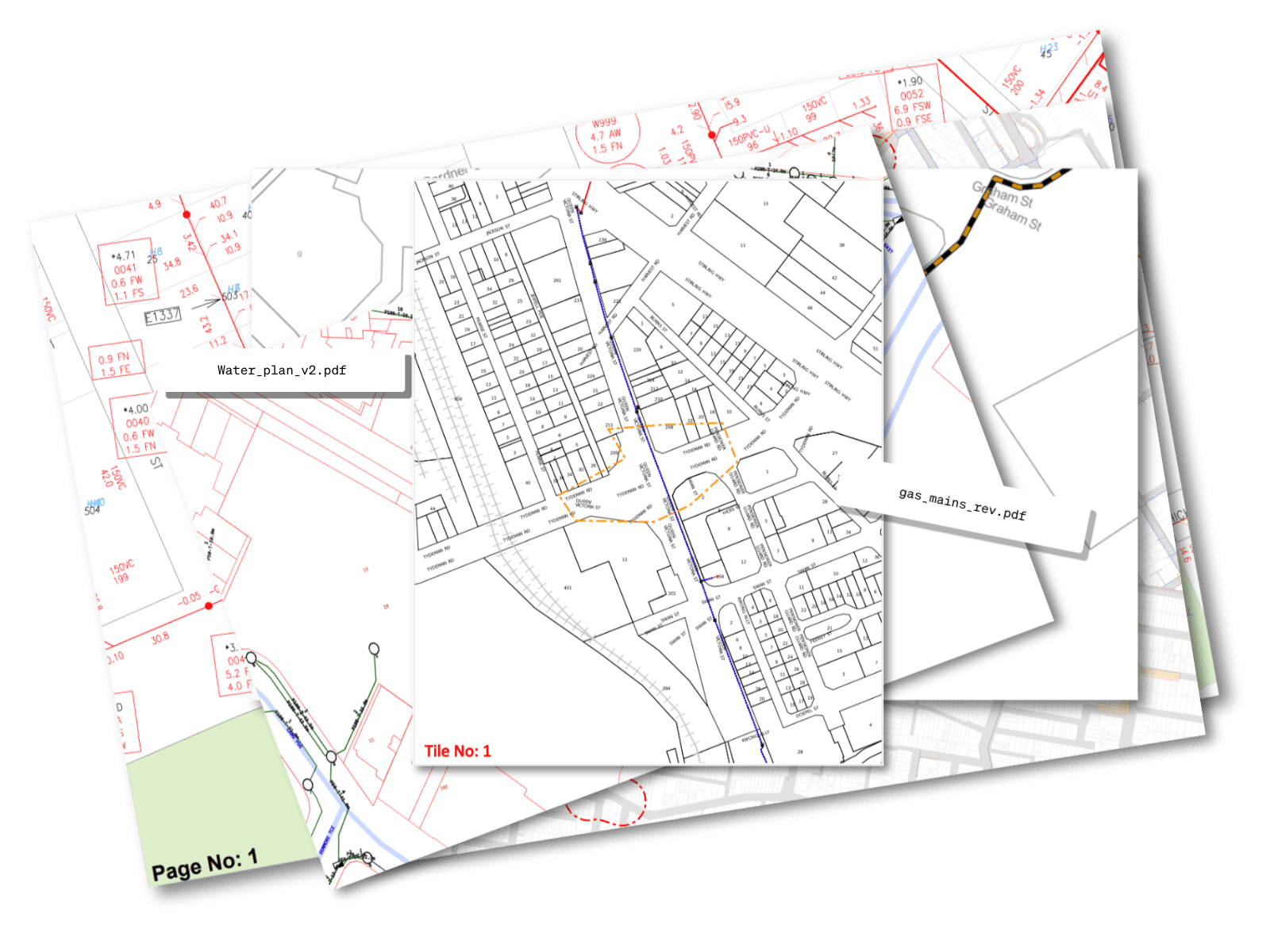
scattered PDF utility records from a BYDA referral

AFTER INGEST

All utilities in one place, digitised, georeferenced and colour-coded to AS5488

all pdf records consolidated and digitised into a single map
ingest logo showing process from scattered utility records to a single map
HOW IT WORKS

1

Upload your dial

Once your account is created, upload your BYDA .zip to the portal.

Once your account is created, upload your BYDA .zip to the portal.

2

We align it

Ingest automatically digitises and aligns all the responses.

Ingest automatically digitises and aligns all the responses.

3

View your map

You get a georeferenced and digital map, ready to share and use on your project.

You get a georeferenced and digital map, ready to share and use on your project.

*Most files are processed automatically.
However, some records may require manual digitisation. Undermaps provides tools to help you digitise those records when needed.

*Most files are processed automatically.
However, some records may require manual digitisation. Undermaps provides tools to help you digitise those records when needed.

The Proof — Burton Contractors Case Study

7.67 Ha

7.67 Ha

Of PDF records digitised

Of PDF records digitised

30

30

Engineering hours saved

Engineering hours saved

$5,000

$5,000

Labour cost saved

Labour cost saved

Using Undermaps has greatly reduced the friction in our workflows to digitise our as-built records. It's saving us time and money in man-hours that were previously spent on this menial, repetitive task.

Chris Burton

Burton Contractors

Using Undermaps has greatly reduced the friction in our workflows to digitise our as-built records. It's saving us time and money in man-hours that were previously spent on this menial, repetitive task.

Chris Burton

Burton Contractors

Simple pricing
SIMPLE PRICING, BASED ON JOB SIZE

$149

Small

Small

$299

Medium

Medium

$499

Large

Large

POA

Very large jobs

Very large jobs

Pricing is based on the area of the job and the number of asset owners within the area.
The price of your job will be calculated at check-out in the Undermaps app before you confirm .

WHAT YOU GET

ONE MAP. EVERY REFERRAL, READY TO USE.

Ingest returns your dial as a single, digitised and georeferenced map with every utility referral consolidated into a single view.

Ingest returns your dial as a single, georeferenced map with every utility aligned to its real-world position. Open it and it’s ready for the field.

Georeferenced & aligned

Georeferenced & aligned

AS5488 colour-coded

AS5488 colour-coded

Original documentation retained

Original documentation retained

Sign up To start using undermaps today.
FAQ

FREQUENTLY ASKED QUESTIONS

How many users can I add to my Ingest map?

Undermaps Ingest allows for unlimited users, so anyone on your project can work off the same plans.

Can I export my map?

Yes, Ingest supports export to GeoJSON and CAD.

How long will my data take to process?

You can expect your files back within 24 hours. The Undermaps team will be in touch during processing to notify you on your expected delivery.

What file formats does Ingest support?

Most files are processed automatically. However, some records may require manual digitisation. Undermaps provides the tools to help you digitise those records when needed.

Is my data secure?

Yes, all data uploaded to Ingest is encrypted in transit and at rest. We follow industry best practices for data security.

How do I get started?

You can sign-up to start using Undermaps today. Fill in your email above to create your account.